There are several types of cloud computing deployment scenarios. The National Institute of Standards and Technology (NIST) is emerging as the preferred provider of the de facto definition of cloud computing and the distribution models, seen here with some ESRI examples.
The public cloud is the most commonly referenced regarding the topic of cloud computing, where the infrastructure and applications are owned by the organization selling cloud services. However, since many traditional vendors and users are not quite ready to jump into public cloud computing or are restricted from doing so, the cloud service tiers are replicated within a private cloud environment, behind the firewall, and maintained within the parameters of the host organization. Many believe that the sweet spot for cost optimization in an organization will rely on a delicate balance of public, or community, and private clouds. However, since this hybrid cloud solution is commonly bound together by proprietary technology, it will only be embraced by enterprise computing in the future as standards are developed.
On-Demand GIS and Mapping: ESRI and the Cloud
ESRI considers cloud computing and technology important in the development and vision of the ArcGIS platform. Several options are available for companies that want to improve productivity and efficiency while reducing expenses and freeing up valuable IT resources to concentrate on newer business initiatives.
ArcGIS Server is a viable candidate in an on-demand architecture. Cached map tiles can be uploaded to cloud computing vendors, such as Amazon Simple Storage Service (S3), to create a data center in the cloud.
ESRI's current SaaS offering is ESRI Business Analyst Online, which allows the consumer to combine GIS technology with extensive demographic, consumer, and business data for the entire United States. This enables the delivery of on-demand analysis, boardroom-ready reports, and maps over the Web. Because ESRI hosts Business Analyst Online, consumers need not worry about managing data or technology updates. Furthermore, ESRI developers can leverage ESRI's PaaS offerings via the ArcGIS Web mapping APIs, such as JavaScript, Flex, and Silverlight/WPF, hosted by ESRI on ArcGIS Online.
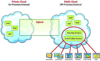
ESRI has been providing software plus services (S+S) for some time, allowing customers to leverage their on-premises solutions with on-demand services. ESRI's ArcGIS Online map and GIS services provide S+S users immediate access to cartographically designed, seamless basemaps to which they can easily add their own data in an ESRI on-premises product. MapIt is another implementation of software plus services, allowing business information to be displayed and more accurately analyzed through access to online data, basemaps, and task services from ESRI and Bing Maps, as well as through support for the Windows Azure Platform and Microsoft's SQL Azure. As a community cloud, the ArcGIS Online Content Sharing Program enables users and organizations to contribute geographic data content. Leveraging Amazon's EC2 and S3 compute and storage services allows ESRI to host the content and provide access 24/7. ArcGIS Explorer users can consume ready-to-use basemaps and layers from ArcGIS Online Services in the S+S model. And ArcLogistics provides software and access to online services that help you create optimal vehicle routes and schedules.
As cloud computing continues to move farther into mainstream IT to become a convention in business, ESRI will continue to offer solutions to allow customers and prospects success in the cloud.
I’ve found blogging to be a great way to publish some unusual thoughts or opinions. I’ve always enjoyed engaging in interesting discussions with people, but you can reach a lot more people via a blog than you can in verbal conversation.
ReplyDeleteCloud Hosting India